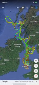
This map shows the travels of one Bardsey Manx Shearwater over eight days – it left its partner on the nest on the island with their egg and returned after eight days at sea to its partner and one day old chick!
The satellite tracking project is being managed by BBFO and Bangor University. Last year seventeen trackers were fitted to Manxies as a pilot project and in 2022 between 40 and 60 will be fitted – 24 during incubation and more later. The map (reproduced again below) shows the extent of the individual’s travels and favoured feeding areas – right up to both the Inner Hebrides and the Western Isles and further north-west out into the Atantic, with trips up the Firth of Clyde and considerable time spent around the Isle of Man. The colour coding on the tracking map indicates rapid travel (green), slowish (amber) and stopped or very slow (red).